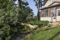
A downed tree limb blocks the entryway of a house on Copeland Avenue after a storm with extreme winds in La Crosse, Wis., Tuesday, July 29, 2025. (Saskia Hatvany/La Crosse Tribune via AP)
Dawn Sands cleans debris off Goddard Street on French Island after a storm with extreme winds in La Crosse, Wis., Tuesday, July 29, 2025. (Saskia Hatvany/La Crosse Tribune via AP)
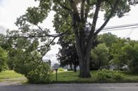
A tree limb is stuck in power lines on Bainbridge Street on French Island after a storm with extreme winds in La Crosse, Wis., Tuesday, July 29, 2025. (Saskia Hatvany/La Crosse Tribune via AP)
Dawn Sands cleans the parking lot at Robin's Nest Bar & Grill after a storm with extreme winds in La Crosse, Wis., Tuesday, July 29, 2025. (Saskia Hatvany/La Crosse Tribune via AP)
Two large trees are uprooted at Veterans Freedom Park after a storm with extreme winds in La Crosse, Wis., Tuesday, July 29, 2025. (Saskia Hatvany/La Crosse Tribune via AP)
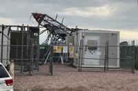
In this image provided by the Lincoln County, S.D., Sheriff's Office, a cell tower sustained damage following strong winds overnight in southern Lincoln County, South Dakota, Tuesday, July 29, 2025. (Sgt. E.J. Colshan/Lincoln County Sheriff's Office via AP)
In this image provided by the Lincoln County, S.D., Sheriff's Office, a cell tower sustained damage following strong winds overnight in southern Lincoln County, South Dakota, Tuesday, July 29, 2025. (Sgt. E.J. Colshan/Lincoln County Sheriff's Office via AP)
A downed tree limb blocks the entryway of a house on Copeland Avenue after a storm with extreme winds in La Crosse, Wis., Tuesday, July 29, 2025. (Saskia Hatvany/La Crosse Tribune via AP)
Dawn Sands cleans debris off Goddard Street on French Island after a storm with extreme winds in La Crosse, Wis., Tuesday, July 29, 2025. (Saskia Hatvany/La Crosse Tribune via AP)
A tree limb is stuck in power lines on Bainbridge Street on French Island after a storm with extreme winds in La Crosse, Wis., Tuesday, July 29, 2025. (Saskia Hatvany/La Crosse Tribune via AP)
Dawn Sands cleans the parking lot at Robin's Nest Bar & Grill after a storm with extreme winds in La Crosse, Wis., Tuesday, July 29, 2025. (Saskia Hatvany/La Crosse Tribune via AP)
Two large trees are uprooted at Veterans Freedom Park after a storm with extreme winds in La Crosse, Wis., Tuesday, July 29, 2025. (Saskia Hatvany/La Crosse Tribune via AP)
In this image provided by the Lincoln County, S.D., Sheriff's Office, a cell tower sustained damage following strong winds overnight in southern Lincoln County, South Dakota, Tuesday, July 29, 2025. (Sgt. E.J. Colshan/Lincoln County Sheriff's Office via AP)
In this image provided by the Lincoln County, S.D., Sheriff's Office, a cell tower sustained damage following strong winds overnight in southern Lincoln County, South Dakota, Tuesday, July 29, 2025. (Sgt. E.J. Colshan/Lincoln County Sheriff's Office via AP)
Strong storms that brought hurricane-force winds to an area stretching from the Upper Plains to the Midwest have been preliminarily classified by the National Weather Service as a derecho, defined as a long-lived line of storms with extreme winds.
The weather service's Storm Prediction Center said Tuesday it made the determination based on local storm reports showing straight-line winds gusting well over 60 mph (97 kph) from South Dakota and into Iowa, Minnesota and western areas of Illinois and Wisconsin from late Monday into early Tuesday. A storm is classified as a derecho if its wind damage swath extends more than 240 miles (386 kilometers) and has wind gusts of at least 58 mph (93 kph) or greater along most of the length of the storm’s path.
Many areas reported gusts of over 75 mph (121 kph). The highest reading appeared to be in northwestern Iowa just before 10 p.m. Monday, when a gust clocked at 99 mph (159 kph) was recorded at Sioux Center.
The high winds tore down trees and tree limbs throughout the region, damaged some buildings and left thousands of customers without power by midday Tuesday. But the overnight derecho was not nearly as destructive as others in recent history, that traveled from eastern Nebraska across Iowa and into Wisconsin and Illinois, reaching wind speeds of a major hurricane and flattening an estimated 100,000 trees in and around Cedar Rapids, Iowa.
A derecho in the Great Plains and Upper Midwest spawned at least 45 tornadoes, caused widespread damage and killed at least five people.
The overnight storms didn't drop as much rain as was feared, meteorologists said.
“It looks like everything certainly stayed under 2 inches," or 5 centimeters, said Alexis Jimenez, a National Weather Service meteorologist in Des Moines, Iowa.
That could change, at least for Iowa, Tuesday night into Wednesday, Jimenez said.
“It’s southwest Iowa’s turn for thunderstorms with heavy rain,” Jimenez said. “We're looking at maybe some more damaging winds. Of course, none of the magnitude as we saw last night.”
The weather service said severe thunderstorms are expected Tuesday into Wednesday from southern Montana into the central High Plains and across much of Nebraska and Iowa.