In this aerial image taken from video provided by WVEC-TV, homes along the Atlantic Coast in Dare County, N.C., are seen, Monday, Aug. 18, 2025, ahead of expected impacts from Hurricane Erin. (WVEC-TV via AP)
As waves from Hurricane Erin crash and “No Swimming” flags flap in the breeze, people walk on the beach in Nags Head, N.C., on Tuesday, Aug. 19, 2025. (AP Photo/Allen G. Breed)
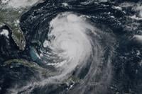
This GOES-19 GeoColor satellite image taken Tuesday, Aug. 19, 2025 at 1:20 p.m. EDT and provided by NOAA, shows Hurricane Erin churning slowly toward the eastern U.S. coast. (NOAA via AP)
Red flags, indicating swimming is prohibited, are raised at the beach in Duck, N.C., Tuesday, Aug. 19, 2025, as precautions are taken ahead of Hurricane Erin. (AP Photo/Pablo Martinez Monsivais)
People walk along the beach as waves as red flags, indicating swimming is prohibited, are raised at the beach in Duck, N.C., Tuesday, Aug. 19, 2025, as precautions are taken ahead of Hurricane Erin. (AP Photo/Pablo Martinez Monsivais)
In this aerial image taken from video provided by WVEC-TV, homes along the Atlantic Coast in Dare County, N.C., are seen, Monday, Aug. 18, 2025, ahead of expected impacts from Hurricane Erin. (WVEC-TV via AP)
As waves from Hurricane Erin crash and “No Swimming” flags flap in the breeze, people walk on the beach in Nags Head, N.C., on Tuesday, Aug. 19, 2025. (AP Photo/Allen G. Breed)
This GOES-19 GeoColor satellite image taken Tuesday, Aug. 19, 2025 at 1:20 p.m. EDT and provided by NOAA, shows Hurricane Erin churning slowly toward the eastern U.S. coast. (NOAA via AP)
Red flags, indicating swimming is prohibited, are raised at the beach in Duck, N.C., Tuesday, Aug. 19, 2025, as precautions are taken ahead of Hurricane Erin. (AP Photo/Pablo Martinez Monsivais)
PMM
People walk along the beach as waves as red flags, indicating swimming is prohibited, are raised at the beach in Duck, N.C., Tuesday, Aug. 19, 2025, as precautions are taken ahead of Hurricane Erin. (AP Photo/Pablo Martinez Monsivais)
RODANTHE, N.C. (AP) — From Florida to New England, people trying to enjoy the last hurrahs of summer along the coast were met with rip-current warnings, closed beaches and in some cases already treacherous waves as Hurricane Erin inched closer Wednesday.
While forecasters remain confident that the center of the monster storm will stay far offshore, the outer edges are expected to bring high winds, large swells and into Friday. But the biggest swells along the East Coast could come as early as Wednesday.
New York City closed its beaches to swimming on Wednesday and Thursday, and New York Gov. Kathy Hochul ordered three state beaches on Long Island to prohibit swimming through Thursday. Several New Jersey beaches also will be temporarily off-limits, while some towns in Delaware have cut off ocean access.
Off Massachusetts, Nantucket Island could see waves of more than 10 feet (3 meters) later this week. But the biggest threat is along the barrier islands of North Carolina’s , where evacuations have been ordered.
Erin has become an unusually large and deceptively worrisome storm, with its tropical storm winds stretching 230 miles (370 kilometers) from its core. Forecasters expect it will grow larger in size as it moves through the Atlantic and curls north.
On Tuesday it lashed the Turks and Caicos Islands, where government services were suspended and residents were ordered to stay home, along with parts of the Bahamas before its expected turn toward Bermuda.
Tropical storm watches were issued for Virginia and North Carolina as well as Bermuda.
Erin lost some strength from previous days and was a Category 2 hurricane with maximum sustained winds around 100 mph (155 kph), the National Hurricane Center in Miami said. It was about 495 miles (795 kilometers) south-southeast of North Carolina’s Cape Hatteras.
On the Outer Banks, Erin's storm surge could swamp roads with waves of 15 feet (4.6 meters). Mandatory evacuations were ordered on Hatteras and Ocracoke Islands. More than 1,800 people had left Ocracoke by ferry since Monday.
North Carolina Gov. Josh Stein warned coastal residents to be prepared to evacuate and declared a state of emergency Tuesday. Bulldozers shored up the dunes, and trucks from the local power company on Ocracoke were on hand to respond to downed wires.
Some side roads already saw some flooding on Hatteras, and the owners of a pier removed a few planks, hoping the storm surge would pass through without tearing it up.
Most residents decided to stay even though memories are still fresh of in 2019, when 7 feet (2.1 meters) of water , county commissioner Randal Mathews said.
Tom Newsom, who runs fishing charters on Hatteras, said has lived there almost 40 years and never evacuated. He was not going to this time either.
Comparing this hurricane to others he has seen, he called this one a “nor’easter on steroids.”
The Outer Banks' thin stretch of low-lying barrier islands jutting into the Atlantic are to storm surges. There are concerns that parts of the main highway could be washed out, leaving some routes impassible for days. And dozens of beach homes already worn down from chronic beach erosion and the loss of protective dunes could be at risk, said David Hallac, superintendent of the Cape Hatteras National Seashore.
Farther south, no evacuations were ordered but some beach access points were closed with water levels up to 3 feet (1 meter) over normal high tides expected for several days.
Climate scientists say Atlantic hurricanes are now much into powerful and catastrophic storms fueled by . Two years ago grew with surprising speed while barreling offshore through the Atlantic, unleashing violent storms and rip currents.
___
Seewer reported from Toledo, Ohio. Associated Press journalists Dave Collins in Hartford, Connecticut; Jeffrey Collins in Columbia, South Carolina; Gary Robertson in Raleigh, North Carolina; Ben Finley in Norfolk, Virginia; Hallie Golden in Seattle; Leah Willingham in Boston; Safiyah Riddle in Montgomery, Alabama; and Julie Walker in New York contributed.