A man smokes a cigarette at the end of Jennette's Pier as waves from Hurricane Erin crash ashore in Nags Head, N.C., on Thursday, Aug. 21, 2025. (AP Photo/Allen G. Breed)
Sebastian Kettner fishes on Jennette's Pier as waves from Hurricane Erin crash ashore in Nags Head, N.C., Thursday, Aug. 21, 2025. (AP Photo/Allen G. Breed)
Surfers try to get in the water, past big waves bolstered by Hurricane Erin, at Rockaway Beach in the Queens borough of New York, Thursday, Aug. 21, 2025. (AP Photo/Seth Wenig)
SW
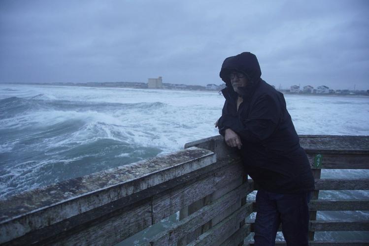
A person watches as waves from Hurricane Erin crash along beach in Duck, N.C., on Thursday, Aug. 21, 2025. (AP Photo/Pablo Martinez Monsivais)
PMM
A surfer rides waves bolstered by Hurricane Erin at Rockaway Beach in the Queens borough of New York, Thursday, Aug. 21, 2025. (AP Photo/Seth Wenig)
RODANTHE, N.C. (AP) ŌĆö Strong winds and waves battered Nantucket and MarthaŌĆÖs Vineyard and dangerous rip currents threatened from the Carolinas to New England as Hurricane Erin made its way farther out to sea Friday.
The storm was forecast to cause possible coastal flooding into the weekend along the East Coast but was also expected to weaken gradually. Despite being twice the size of an average hurricane, Erin so far has managed to thread the needle through the Atlantic between the East Coast and several island nations, limiting its destructiveness.
On North CarolinaŌĆÖs , waves breached dunes in the town of Kill Devil Hills on Thursday evening, and water and sand pooled on Highway 12.
Although damage assessments were still underway, the low-lying islands appeared to have dodged widespread trouble.
A tropical storm warning remained active on Bermuda, where residents and tourists were told to stay out of the water through Friday. But warnings along the coasts of North Carolina and Virginia were discontinued.
Communities along the mid-Atlantic and southern New England coast could see tropical storm-force wind gusts through early Friday, according to the National Hurricane Center in Miami.
The National Weather Service issued coastal flood warnings for places as far north as New York and New Jersey.
Beaches were closed to swimming Thursday in New York City, but more than a dozen surfers still rode waves at Rockaway Beach in Queens. Scott Klossner, who lives nearby, said conditions were great for experienced surfers.
ŌĆ£You wait all year round for these kinds of waves. ItŌĆÖs challenging, really hard to stay in one place, because thereŌĆÖs a heavy, heavy, heavy rip,ŌĆØ he said. ŌĆ£But this is what surfers want ŌĆö a hurricane that comes but doesnŌĆÖt destroy my house? IŌĆÖll take that.ŌĆØ
The Outer Banks ŌĆö essentially sand dunes sticking out of the ocean a few feet above sea level ŌĆö to erosion. Storm surges can cut through them, washing tons of sand and debris onto roads and sometimes breaking up pavement and creating new inlets.
The dunes and beach took a beating the last two days, but Dare County Manager Bobby Outten said there have been no new inlets with Erin or significant structural damage to homes or businesses.
ŌĆ£All in all itŌĆÖs not as bad as it could have been,ŌĆØ Outten said. ŌĆ£Hopefully the worst of it is behind us.ŌĆØ
On JennetteŌĆÖs Pier in Nags Head, where sustained winds reached 45 mph (72 kph), dozens of onlookers snapped photos of the huge waves crashing into the structure amid driving rain.
ŌĆ£This is nature at her best,ŌĆØ Nags Head resident David Alan Harvey said. ŌĆ£I love this. I love these storms.ŌĆØ
Erin has fluctuated in intensity since forming nearly a week ago but remained unusually large, stretching across more than 600 miles (965 kilometers).
It was still a Category 2 storm with maximum sustained winds around 100 mph (160 kph), the hurricane center said. Erin was about 535 miles (860 kilometers) south-southwest of Halifax, Nova Scotia.
So-called like Erin, which originate near those islands off the west coast of Africa, cross thousands of miles of warm ocean and are some of the most dangerous to North America.
___
Seewer reported from Toledo, Ohio. Associated Press journalists Tammy Webber in Fenton, Michigan; Jeffrey Collins in Columbia, South Carolina; Kathy McCormack in Concord, New Hampshire; Julie Walker in New York; and Leah Willingham in Boston contributed.
___ The Associated PressŌĆÖ climate and environmental coverage receives financial support from multiple private foundations. AP is solely responsible for all content. Find APŌĆÖs for working with philanthropies, a list of supporters and funded coverage areas at .