FILE - A bulldozer clears sand from N.C. highway 12, Sunday, Sept. 21, 2003, in Kill Devil Hills, N.C., after Hurricane Isabel hit North Carolina's Outer Banks. (AP Photo/Bob Jordan)
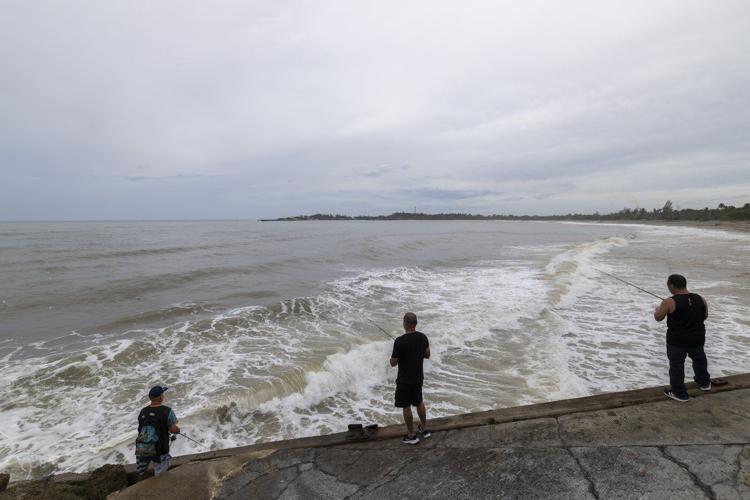
People fish along the shore in Arecibo, Puerto Rico, as Hurricane Erin brings rains to the island, Sunday, Aug. 17, 2025. (AP Photo/Alejandro Granadillo)
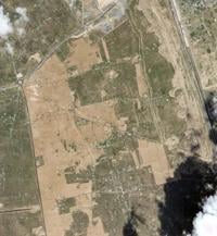
In this aerial image taken from video provided by WVEC-TV, homes along the Atlantic Coast in Dare County, N.C., are seen, Monday, Aug. 18, 2025, ahead of expected impacts from Hurricane Erin. (WVEC-TV via AP)
In this image taken from video provided by WVEC-TV, a sign warning against beach access is posted in Dare County, N.C., Monday, Aug. 18, 2025, ahead of expected impacts from Hurricane Erin. (WVEC-TV via AP)
In this image taken from video provided by WVEC-TV, a vehicle with a trailer is traveling on Highway 12 in Dare County, N.C., Monday, Aug. 18, 2025, ahead of expected impacts from Hurricane Erin. (WVEC-TV via AP)
Red flags, indicating swimming is prohibited, are raised at the beach in Duck, N.C., Tuesday, Aug. 19, 2025, as precautions are taken ahead of Hurricane Erin. (AP Photo/Pablo Martinez Monsivais)
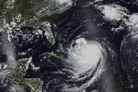
In this Monday, Aug. 18, 2025 satellite image released by NASA, Hurricane Erin continues its slow west-northwest trajectory across the Atlantic Ocean. (NASA Worldview, Earth Observing System Data and Information System (EOSDIS) via AP)
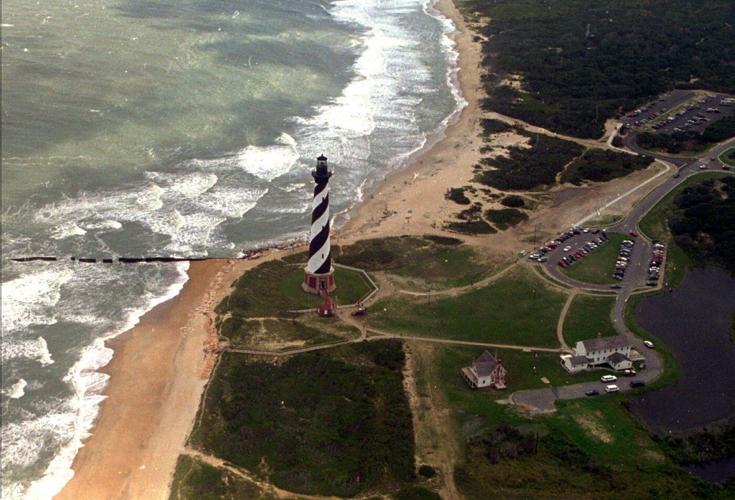
FILE - The Cape Hatteras lighthouse stands, Aug. 29, 1995 on the Outer Banks of North Carolina. (AP Photo/Ruth Fremson, File)
RAF
FILE - A bulldozer clears sand from N.C. highway 12, Sunday, Sept. 21, 2003, in Kill Devil Hills, N.C., after Hurricane Isabel hit North Carolina's Outer Banks. (AP Photo/Bob Jordan)
CMP BJ
People fish along the shore in Arecibo, Puerto Rico, as Hurricane Erin brings rains to the island, Sunday, Aug. 17, 2025. (AP Photo/Alejandro Granadillo)
RE
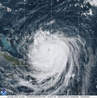
This image provided by the National Oceanic and Atmospheric Administration (NOAA) shows Hurricane Erin on Monday, Aug. 18, 2025. (NOAA via AP)
In this aerial image taken from video provided by WVEC-TV, homes along the Atlantic Coast in Dare County, N.C., are seen, Monday, Aug. 18, 2025, ahead of expected impacts from Hurricane Erin. (WVEC-TV via AP)
In this image taken from video provided by WVEC-TV, a sign warning against beach access is posted in Dare County, N.C., Monday, Aug. 18, 2025, ahead of expected impacts from Hurricane Erin. (WVEC-TV via AP)
In this image taken from video provided by WVEC-TV, a vehicle with a trailer is traveling on Highway 12 in Dare County, N.C., Monday, Aug. 18, 2025, ahead of expected impacts from Hurricane Erin. (WVEC-TV via AP)
Red flags, indicating swimming is prohibited, are raised at the beach in Duck, N.C., Tuesday, Aug. 19, 2025, as precautions are taken ahead of Hurricane Erin. (AP Photo/Pablo Martinez Monsivais)
KS
In this Monday, Aug. 18, 2025 satellite image released by NASA, Hurricane Erin continues its slow west-northwest trajectory across the Atlantic Ocean. (NASA Worldview, Earth Observing System Data and Information System (EOSDIS) via AP)
RODANTHE, N.C. (AP) — Hurricane Erin chugged slowly toward the eastern U.S. coast Tuesday, stirring up treacherous waves that already have forced dozens of beach rescues days before the biggest storm surges are expected.
While forecasters remain confident the center of the monster storm will remain far offshore, the outer edges are likely to bring damaging tropical-force winds, large swells and .
Warnings about rip currents have been posted from Florida to the New England coast, but the biggest threat is along the barrier islands of North Carolina’s where evacuations have been ordered.
Off the coast of Massachusetts, Nantucket Island could see waves of more than 10 feet (3 meters) later this week. In New Jersey, towns are closing some beaches to swimming.
“Enjoy the shore, enjoy this beautiful weather but stay out of the water,” Gov. Phil Murphy said Tuesday.
Erin has become an unusually large and deceptively worrisome storm while moving through the Caribbean, with its tropical storm winds stretching 200 miles (320 kilometers) from its core. Forecasters expect it will grow larger in size as it moves through the Atlantic and curls north.
It continued to lash the Turks and Caicos Islands on Tuesday, where government services were suspended a day earlier and residents were ordered to stay home, along with parts of the Bahamas before it’s expected to turn toward Bermuda and the U.S.
By Tuesday, Erin had lost some strength from previous days and dropped to a Category 2 hurricane with maximum sustained winds of 105 mph (170 kph), the National Hurricane Center in Miami said. It was about 650 miles (1,050 kilometers) southwest of Bermuda.
Rough ocean conditions already have been seen along the U.S. coast — at least 60 swimmers were rescued from rip currents Monday at Wrightsville Beach, near Wilmington, North Carolina.
The biggest swells along the East Coast are expected to develop Wednesday and last into Thursday.
Two years ago, grew with surprising speed while barreling offshore through the Atlantic, unleashing violent storms and rip currents up and down the seaboard.
Climate scientists say Atlantic hurricanes are now much into powerful and catastrophic storms fueled by oceans.
On North Carolina’s Outer Banks, local leaders said Erin's storm surge could swamp roads with waves of 15 feet (4.6 meters). Mandatory evacuations were ordered on Hatteras and Ocracoke Islands, and more than 1,800 people had left Ocracoke by ferry since Monday.
Bulldozers were busy shoring up the dunes, and on Hatteras, the owners of a pier removed a few planks, hoping the storm surge will pass through without tearing up the structure.
Holly Andrzejewski, who just bought a bed-and-breakfast on Hatteras Island with her husband, said they spent the last few days bringing in all the outdoor furniture and making sure there were generators, extra water and flashlights.
“It's just one of those things where you know this is always a possibility and it could happen, and you just make the best out of it. Otherwise you wouldn’t live at the beach,” she said.
The Outer Banks' thin stretch of low-lying barrier islands that jut into the Atlantic Ocean are to storm surges. There are concerns that several days of heavy surf, high winds and waves could wash out parts of the main highway, leaving some routes impassible for days.
___
Seewer reported from Toledo, Ohio. Associated Press journalists Ben Finley in Norfolk, Virginia; Hallie Golden in Seattle; Leah Willingham in Boston; Safiyah Riddle in Montgomery, Alabama; and Julie Walker in New York contributed to this report.